Two potential tropical cyclones are brewing in the Atlantic, posing a double threat to regions already bracing for an active hurricane season. Forecasters are closely monitoring two distinct weather disturbances, one in the Gulf of Mexico and another further east in the Atlantic, both exhibiting the potential to develop into tropical storms or even hurricanes.
Atlantic Braces for Potential Double Tropical Threat
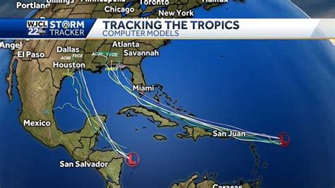
The Atlantic basin is under close scrutiny as two separate weather systems show signs of intensification, raising concerns about the possibility of twin tropical cyclones simultaneously impacting the region. According to the National Hurricane Center (NHC), a disturbance in the Gulf of Mexico and another in the central Atlantic are being monitored for potential development into tropical storms or hurricanes. This unusual dual threat underscores predictions of an above-average hurricane season.
The system in the Gulf of Mexico, currently designated as an area of investigation, is expected to move westward, potentially impacting the coasts of Texas and Louisiana. The NHC indicates a medium chance of formation within the next 48 hours and a high chance within the next seven days. Conditions are favorable for development as the system moves over warm Gulf waters. Residents along the Gulf Coast are urged to monitor forecasts and be prepared to take necessary precautions.
Meanwhile, a tropical wave in the central Atlantic is also gaining strength. This system is further out to sea, making its potential trajectory less certain. However, models suggest it could move westward, potentially impacting the Caribbean islands or even the U.S. East Coast. The NHC is giving this system a low chance of formation in the next 48 hours but a medium chance within the next seven days.
The development of two simultaneous tropical systems is not unprecedented, but it highlights the increased activity anticipated this hurricane season. Factors contributing to this heightened activity include warmer-than-average ocean temperatures and favorable atmospheric conditions.
“We are seeing a combination of factors that are conducive to tropical cyclone formation,” explained a meteorologist from the NHC. “These include low wind shear, high sea surface temperatures, and a favorable atmospheric environment.”
Coastal communities from the Gulf Coast to the Caribbean and the East Coast are advised to stay informed and prepared. Emergency management agencies are closely monitoring both systems and coordinating preparedness efforts. Residents are encouraged to review their hurricane preparedness plans, stock up on essential supplies, and stay tuned to local weather updates.
The NHC will continue to provide regular updates on the development and potential impacts of both systems. The next few days will be crucial in determining their paths and intensity.
Gulf of Mexico Disturbance
The disturbance in the Gulf of Mexico is currently the more immediate threat. Its proximity to land and the favorable conditions in the Gulf make it likely to develop into a tropical storm. Water temperatures in the Gulf are significantly above average, providing ample energy for the storm to intensify. Additionally, wind shear is relatively low, allowing the storm to organize and strengthen.
The potential impact zone for this system includes the coasts of Texas, Louisiana, Mississippi, Alabama, and Florida. However, the exact location of landfall is still uncertain. Forecast models show a range of possibilities, but the consensus is that the system will move westward and eventually make landfall somewhere along the Gulf Coast.
Residents in these areas should be prepared for heavy rainfall, strong winds, and potential flooding. Storm surge is also a significant concern, particularly in low-lying coastal areas. Emergency management officials are urging residents to evacuate if necessary and to take precautions to protect their property.
“We are closely monitoring the system in the Gulf and are coordinating with local officials to ensure that everyone is prepared,” said a representative from the Federal Emergency Management Agency (FEMA). “We urge residents to heed the warnings of local authorities and to take necessary precautions to protect themselves and their families.”
The system’s potential to disrupt oil and gas operations in the Gulf is also being closely watched. The Gulf of Mexico is a major hub for energy production, and a strong storm could disrupt operations and cause significant economic damage. Energy companies are taking precautions to protect their facilities and personnel.
Central Atlantic Tropical Wave
The tropical wave in the central Atlantic is less of an immediate threat, but it still warrants close monitoring. This system is further out to sea, and its potential trajectory is less certain. However, forecast models suggest that it could move westward and eventually impact the Caribbean islands or even the U.S. East Coast.
The conditions in the central Atlantic are also favorable for development. Water temperatures are warm, and wind shear is relatively low. However, the system is still disorganized, and it is uncertain whether it will develop into a tropical storm.
If the system does develop, it could pose a threat to the Caribbean islands. These islands are particularly vulnerable to tropical cyclones due to their small size and low elevation. Residents in the Caribbean should monitor forecasts and be prepared to take necessary precautions.
The system could also eventually impact the U.S. East Coast. However, the track of the storm is still uncertain, and it is too early to say for sure whether it will make landfall in the U.S. Residents along the East Coast should monitor forecasts and be prepared to take necessary precautions.
Hurricane Season Outlook
The development of these two potential tropical cyclones underscores the predictions of an above-average hurricane season. The National Oceanic and Atmospheric Administration (NOAA) has predicted that this hurricane season will be more active than usual due to warmer-than-average ocean temperatures and favorable atmospheric conditions.
Warmer ocean temperatures provide more energy for tropical cyclones to develop and intensify. Low wind shear allows storms to organize and strengthen. A favorable atmospheric environment also contributes to storm development.
“We are expecting an active hurricane season this year,” said a scientist from NOAA. “The conditions are ripe for the formation of strong tropical cyclones.”
The Atlantic hurricane season officially runs from June 1 to November 30. However, tropical cyclones can form outside of these dates. It is important for residents in coastal areas to be prepared for the possibility of a hurricane at any time.
Preparedness Measures
Residents in coastal areas should take the following preparedness measures:
- Review their hurricane preparedness plans.
- Stock up on essential supplies, such as food, water, and medicine.
- Secure their homes and property.
- Stay tuned to local weather updates.
- Evacuate if necessary.
Emergency management agencies are closely monitoring both systems and coordinating preparedness efforts. Residents are encouraged to heed the warnings of local authorities and to take necessary precautions to protect themselves and their families.
Impact on Oil and Gas Industry
The Gulf of Mexico is a major hub for oil and gas production, and a strong storm could disrupt operations and cause significant economic damage. Energy companies are taking precautions to protect their facilities and personnel.
Companies are evacuating workers from offshore platforms and securing equipment. They are also monitoring the storm closely and coordinating with government agencies.
The disruption of oil and gas production could lead to higher prices at the pump. However, the impact on prices will depend on the severity of the storm and the length of the disruption.
Impact on Travel
The development of these two potential tropical cyclones could also impact travel plans. Airlines may cancel or delay flights to and from affected areas. Cruise ships may also alter their itineraries.
Travelers should check with their airlines and cruise lines for updates on their travel plans. They should also be prepared for potential delays and disruptions.
Historical Context of Dual Tropical Systems
While the simultaneous development of two tropical systems is not an everyday occurrence, it is not unprecedented in the history of Atlantic hurricane seasons. Several instances of multiple tropical cyclones existing concurrently have been documented, each with varying degrees of impact.
One notable example is the 1995 Atlantic hurricane season, which featured several periods of multiple active storms. This season was particularly active, with 19 named storms, 11 hurricanes, and 5 major hurricanes. The simultaneous presence of multiple storms stretched resources and posed significant challenges for forecasting and disaster response.
Another significant year was 2020, which broke records for the number of named storms. At times, there were multiple tropical cyclones active simultaneously, requiring the NHC to closely monitor and issue warnings for multiple areas. The rapid succession of storms exhausted the pre-determined list of names, leading to the use of the Greek alphabet for the first time since 2005.
These historical examples underscore the importance of preparedness and vigilance during hurricane season, especially when multiple systems are active. The presence of two or more storms can complicate forecasting efforts, increase the demand on resources, and heighten the risk of widespread impacts.
The Role of Climate Change
Scientists have been studying the relationship between climate change and tropical cyclone activity for years, and the emerging consensus is that climate change is likely to increase the intensity of hurricanes. Warmer ocean temperatures, which are a direct result of climate change, provide more energy for tropical cyclones to develop and intensify. Additionally, changes in atmospheric circulation patterns could also contribute to more intense storms.
While it is difficult to attribute any single storm to climate change, the overall trend is clear: we can expect to see more intense hurricanes in the future. This means that coastal communities need to be even more prepared for the potential impacts of these storms.
The potential increase in hurricane intensity is not the only concern. Climate change is also causing sea levels to rise, which means that storm surge will be even more damaging. Additionally, changes in rainfall patterns could lead to more flooding during hurricanes.
The combination of more intense hurricanes, higher sea levels, and increased rainfall makes climate change a significant threat to coastal communities. It is important for these communities to take steps to adapt to the changing climate, such as building seawalls, raising homes, and improving drainage systems.
Economic Impacts of Tropical Cyclones
Tropical cyclones can have a devastating impact on the economy. They can cause billions of dollars in damage to homes, businesses, and infrastructure. They can also disrupt tourism, agriculture, and other industries.
The economic impact of a tropical cyclone depends on several factors, including the intensity of the storm, the location of landfall, and the preparedness of the affected communities. For example, a major hurricane that makes landfall in a densely populated area can cause significantly more damage than a weaker storm that makes landfall in a sparsely populated area.
The economic impact of a tropical cyclone can be felt for years after the storm has passed. It can take a long time for communities to rebuild and recover. Additionally, the economic impact can ripple through the entire economy, as businesses struggle to recover and consumers cut back on spending.
The economic impact of tropical cyclones is a major concern for coastal communities. It is important for these communities to take steps to mitigate the economic risks of these storms, such as investing in infrastructure improvements, developing disaster preparedness plans, and promoting economic diversification.
The Importance of Accurate Forecasting
Accurate forecasting is crucial for mitigating the impacts of tropical cyclones. The NHC uses a variety of tools and techniques to forecast the track and intensity of these storms. These tools include satellite imagery, radar data, and computer models.
The accuracy of hurricane forecasts has improved significantly in recent years. However, there is still room for improvement. In particular, it is difficult to forecast the intensity of hurricanes. This is because the processes that govern hurricane intensification are complex and not fully understood.
Despite the challenges, the NHC is committed to improving the accuracy of hurricane forecasts. This will help to ensure that coastal communities have the information they need to prepare for these storms.
Community Resilience and Recovery
Building community resilience is essential for minimizing the impacts of tropical cyclones. Resilient communities are able to withstand the impacts of these storms and recover quickly.
There are several factors that contribute to community resilience. These include strong leadership, effective communication, and a well-coordinated disaster response. Additionally, resilient communities have strong social networks and a sense of community.
After a tropical cyclone has passed, it is important for communities to focus on recovery. This includes rebuilding damaged homes and businesses, restoring infrastructure, and providing assistance to those who have been affected by the storm.
The recovery process can be long and challenging. However, with strong leadership, effective communication, and a well-coordinated response, communities can recover from these storms and build back even stronger.
Long-Term Strategies for Coastal Protection
Beyond immediate preparedness and response, long-term strategies are essential for protecting coastal communities from the increasing threat of tropical cyclones. These strategies include:
- Coastal Restoration: Restoring natural coastal features such as wetlands and barrier islands can provide a natural buffer against storm surge and wave action. These ecosystems absorb energy from waves and reduce the impact on inland areas.
- Infrastructure Improvements: Upgrading infrastructure, such as seawalls, levees, and drainage systems, can help to protect coastal communities from flooding. These improvements should be designed to withstand the impacts of more intense storms.
- Land Use Planning: Implementing land use planning policies that restrict development in vulnerable coastal areas can help to reduce the risk of damage from tropical cyclones. This includes limiting construction in floodplains and promoting denser development in safer areas.
- Building Codes: Strengthening building codes to require that new construction be more resistant to wind and flood damage can help to protect homes and businesses. This includes requiring stronger roofing systems, impact-resistant windows, and elevated foundations.
- Community Education and Outreach: Educating residents about the risks of tropical cyclones and how to prepare for them is essential for building community resilience. This includes providing information about evacuation routes, emergency supplies, and insurance coverage.
By implementing these long-term strategies, coastal communities can reduce their vulnerability to tropical cyclones and protect their economies and quality of life. The combination of preparedness, response, and long-term mitigation strategies is crucial for safeguarding coastal regions in the face of increasing climate-related threats.
FAQ:
-
What are the chances of these two systems becoming hurricanes?
- The NHC is giving the Gulf of Mexico system a medium chance of formation within 48 hours and a high chance within seven days. The system in the central Atlantic has a low chance of formation within 48 hours but a medium chance within seven days. While development into a hurricane is possible for either system, it’s not guaranteed. “We are seeing a combination of factors that are conducive to tropical cyclone formation,” explained a meteorologist from the NHC. “These include low wind shear, high sea surface temperatures, and a favorable atmospheric environment.”
-
Which areas are most at risk from these potential storms?
- The Gulf Coast states, including Texas, Louisiana, Mississippi, Alabama, and Florida, are at risk from the system in the Gulf of Mexico. The tropical wave in the central Atlantic could potentially impact the Caribbean islands or the U.S. East Coast, although its track is less certain.
-
How can I prepare for a potential hurricane?
- Review your hurricane preparedness plan. Stock up on essential supplies, such as food, water, and medicine. Secure your home and property. Stay tuned to local weather updates and evacuate if necessary. The Federal Emergency Management Agency (FEMA) urges residents to “heed the warnings of local authorities and to take necessary precautions to protect themselves and their families.”
-
Where can I find the latest updates on these storms?
- The National Hurricane Center (NHC) provides regular updates on the development and potential impacts of both systems. You can find these updates on the NHC website or through local news outlets.
-
Is climate change making hurricanes more frequent and intense?
- Scientists believe that climate change is likely to increase the intensity of hurricanes. Warmer ocean temperatures, which are a direct result of climate change, provide more energy for tropical cyclones to develop and intensify. While it is difficult to attribute any single storm to climate change, the overall trend is clear: we can expect to see more intense hurricanes in the future.