Two potential tropical disturbances are brewing in the Atlantic, posing a double threat to coastal regions as meteorologists monitor their development and potential paths.
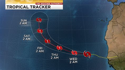
The Atlantic basin is showing signs of increased tropical activity with two distinct weather systems under observation. The National Hurricane Center (NHC) is tracking a tropical wave located several hundred miles east of the Lesser Antilles and another system emerging off the African coast, raising concerns about potential tropical cyclones forming in the coming days.
Tropical Wave East of the Lesser Antilles
The first system, a tropical wave, is currently situated several hundred miles east of the Lesser Antilles. According to the NHC, “Environmental conditions appear conducive for gradual development, and a tropical depression could form later this week or this weekend while it moves westward to west-northwestward at 10 to 15 mph, toward the adjacent waters of the Lesser Antilles.” As of the latest advisory, it has a medium chance of formation through 48 hours and a medium chance through 7 days.
This system is expected to bring unsettled weather to the Lesser Antilles as it approaches. Residents in these islands are advised to monitor the progress of the wave and stay informed about potential impacts, including increased rainfall and gusty winds. The specific intensity and track of the system remain uncertain at this stage, highlighting the need for continued vigilance.
“Regardless of development, this system is expected to bring an increase in showers and thunderstorms to portions of the Lesser Antilles beginning on Wednesday,” the NHC stated.
Tropical Wave Emerging off Africa
The second area of interest is a tropical wave forecast to emerge off the west coast of Africa in the next day or so. The NHC notes that “Some gradual development of this system is possible thereafter while it moves generally westward or west-northwestward across the eastern tropical Atlantic.” As of now, the NHC gives this system a low chance of formation through 48 hours and a low chance through 7 days.
While the long-term development potential of this African wave is still uncertain, its emergence warrants close monitoring. The interplay of atmospheric conditions and its interaction with the ocean will determine whether it strengthens into a more organized tropical system. Given the vast expanse of the Atlantic, any system originating off Africa has the potential to impact a wide range of areas, including the Caribbean and the U.S. East Coast.
Implications and Preparations
The emergence of these two tropical systems underscores the importance of preparedness during hurricane season, which officially runs from June 1 to November 30. Coastal communities, in particular, are urged to review their hurricane plans, ensure they have adequate supplies, and stay informed about the latest forecasts and advisories from the NHC and local weather authorities.
“Now is the time to make sure you have a plan,” emphasizes a spokesperson from the Federal Emergency Management Agency (FEMA). “Don’t wait until a storm is imminent. Review your evacuation routes, check your emergency kits, and ensure your family knows what to do in the event of a hurricane.”
The development of these systems also highlights the complex dynamics of tropical meteorology. Factors such as sea surface temperatures, wind shear, and atmospheric stability all play crucial roles in determining whether a tropical disturbance intensifies into a tropical storm or hurricane. Meteorologists use sophisticated computer models and observational data to track these factors and predict the behavior of tropical systems.
Historical Context and Recent Seasons
The Atlantic hurricane season has historically produced numerous impactful storms, some causing widespread devastation. Recent years have seen a trend of increased activity, with several above-average seasons in terms of the number of named storms and major hurricanes. Experts attribute this heightened activity to a combination of factors, including warmer ocean temperatures and favorable atmospheric patterns.
The 2020 Atlantic hurricane season was particularly active, with a record-breaking 30 named storms, including several major hurricanes that caused significant damage across the Caribbean and the United States. The 2021 and 2022 seasons were also above average, reinforcing the need for constant vigilance and preparedness. While it’s impossible to predict the exact characteristics of any given season, the overall trend suggests that coastal communities should remain proactive in mitigating the risks associated with hurricanes.
The 2023 Atlantic hurricane season was also active, exceeding initial predictions. It featured several intense hurricanes, some of which caused significant damage and disruption. This further emphasizes the importance of staying informed and prepared.
The Role of Climate Change
Scientists are increasingly linking climate change to the intensity and frequency of tropical cyclones. Warmer ocean temperatures provide more energy for these storms to develop, potentially leading to stronger and more destructive hurricanes. Sea level rise also exacerbates the impacts of storm surge, increasing the risk of coastal flooding. While climate change is not the sole driver of hurricane activity, it is believed to be a significant contributing factor, and its influence is expected to grow in the future.
Continued research and monitoring are essential to better understand the complex relationship between climate change and tropical cyclones. This knowledge is crucial for developing effective strategies to mitigate the risks associated with these storms and protect vulnerable coastal communities.
Monitoring and Forecasting Technologies
The NHC and other meteorological organizations rely on a variety of advanced technologies to monitor and forecast tropical cyclones. These include satellites, weather balloons, aircraft reconnaissance, and sophisticated computer models. Satellites provide a continuous view of the Earth’s atmosphere, allowing meteorologists to track the movement and development of tropical disturbances. Weather balloons carry instruments that measure temperature, humidity, and wind speed at different altitudes, providing valuable data for weather forecasting. Aircraft reconnaissance involves flying specially equipped planes into tropical storms to collect detailed measurements of their intensity and structure.
Computer models use mathematical equations to simulate the behavior of the atmosphere and oceans, allowing meteorologists to predict the future track and intensity of tropical cyclones. These models are constantly being refined and improved, based on new data and research. Despite these advances, forecasting the behavior of tropical cyclones remains a challenging task, due to the complex interplay of factors involved.
Community Preparedness and Resilience
Effective hurricane preparedness requires a coordinated effort involving individuals, communities, and government agencies. Individuals should develop a hurricane plan, assemble an emergency kit, and stay informed about the latest forecasts and advisories. Communities should implement comprehensive emergency management plans, including evacuation procedures, shelter locations, and communication strategies. Government agencies play a crucial role in providing resources, coordinating response efforts, and educating the public about hurricane safety.
Building resilience to hurricanes involves investing in infrastructure that can withstand the impacts of strong winds and flooding. This includes strengthening buildings, improving drainage systems, and restoring coastal ecosystems. Resilience also involves promoting economic diversification and social equity, to ensure that vulnerable populations are better able to cope with the impacts of hurricanes.
Detailed Look at Tropical Cyclone Formation
Tropical cyclones, including hurricanes, are complex meteorological phenomena that require specific conditions to form and intensify. These conditions include warm ocean waters, a moist atmosphere, and low wind shear. Warm ocean waters provide the energy that fuels tropical cyclones, while a moist atmosphere provides the necessary moisture for cloud formation and precipitation. Low wind shear, which is the difference in wind speed and direction at different altitudes, allows the storm to organize and intensify.
The formation process typically begins with a tropical disturbance, which is an area of low pressure with disorganized thunderstorms. If the disturbance is located over warm ocean waters and the atmospheric conditions are favorable, it may begin to develop into a tropical depression. A tropical depression is a tropical cyclone with maximum sustained winds of 38 miles per hour or less.
If the tropical depression continues to intensify, it may become a tropical storm. A tropical storm is a tropical cyclone with maximum sustained winds of 39 to 73 miles per hour. Tropical storms are given names, which are assigned in alphabetical order each year.
If the tropical storm continues to intensify, it may become a hurricane. A hurricane is a tropical cyclone with maximum sustained winds of 74 miles per hour or greater. Hurricanes are classified into five categories, based on their intensity, using the Saffir-Simpson Hurricane Wind Scale. Category 1 hurricanes have winds of 74 to 95 miles per hour, while Category 5 hurricanes have winds of 157 miles per hour or greater.
The Saffir-Simpson Hurricane Wind Scale
The Saffir-Simpson Hurricane Wind Scale is a 1-to-5 rating based on a hurricane’s sustained wind speed. This scale estimates potential property damage. Hurricanes reaching Category 3 and higher are considered major hurricanes because of their potential for significant loss of life and damage. Category 1 and 2 storms are still dangerous, however, and require precautionary measures.
-
Category 1: 74-95 mph (119-153 km/h) – Very dangerous winds will produce some damage: Well-constructed frame homes could have damage to roof, shingles, vinyl siding and gutters. Large branches of trees will snap and shallowly rooted trees may be toppled. Extensive damage to power lines and poles likely will result in power outages that could last a few to several days.
-
Category 2: 96-110 mph (154-177 km/h) – Extremely dangerous winds will cause extensive damage: Well-constructed frame homes could sustain major roof and siding damage. Many shallowly rooted trees will be snapped or uprooted and block numerous roads. Near-total power loss is expected with outages that could last from several days to weeks.
-
Category 3: 111-129 mph (178-208 km/h) – Devastating damage will occur: Well-built framed homes may incur major damage or removal of roof decking and gable ends. Many trees will be snapped or uprooted, blocking numerous roads. Electricity and water will be unavailable for several days to weeks after the storm passes.
-
Category 4: 130-156 mph (209-251 km/h) – Catastrophic damage will occur: Well-built homes can sustain severe damage with loss of most of the roof structure and/or some exterior walls. Most trees will be snapped or uprooted and power poles downed. Fallen trees and power poles will isolate residential areas. Power outages will last weeks to possibly months. Most of the area will be uninhabitable for weeks or months.
-
Category 5: 157 mph or higher (252 km/h or higher) – Catastrophic damage will occur: A high percentage of framed homes will be destroyed, with total roof failure and wall collapse. Fallen trees and power poles will isolate residential areas. Power outages will last for weeks to possibly months. Most of the area will be uninhabitable for weeks or months.
The Importance of Evacuation Orders
Local authorities issue evacuation orders when a hurricane is expected to pose a significant threat to life and property. Evacuation orders are based on a variety of factors, including the storm’s intensity, track, and potential impacts. It is crucial to heed evacuation orders and follow the instructions of local officials.
Evacuating early can save lives and reduce the strain on emergency services. When evacuating, it is important to bring essential items, such as medications, important documents, and a supply of food and water. It is also important to secure your home by boarding up windows and bringing in outdoor furniture.
After the Storm
The aftermath of a hurricane can be just as dangerous as the storm itself. Downed power lines, flooding, and debris can pose significant hazards. It is important to exercise caution and follow the instructions of local officials.
Avoid driving through flooded areas, as the water may be deeper than it appears. Stay away from downed power lines, as they can be deadly. Report any damage to your property to your insurance company and local authorities.
Long-Term Recovery
Recovering from a hurricane can be a long and challenging process. It is important to be patient and seek support from family, friends, and community organizations. Government agencies and non-profit organizations offer a variety of resources to help individuals and communities recover from hurricanes. These resources include financial assistance, housing assistance, and counseling services.
Conclusion
The emergence of two potential tropical systems in the Atlantic serves as a reminder of the ever-present threat posed by hurricanes. Staying informed, being prepared, and heeding the advice of local authorities are crucial for mitigating the risks associated with these powerful storms. As we navigate the hurricane season, vigilance and proactive measures are our best defense against the potential impacts of these natural disasters. Remember to closely monitor weather updates from reputable sources such as the National Hurricane Center and local news outlets.
Frequently Asked Questions (FAQ)
1. How likely is it that these tropical waves will develop into hurricanes?
The National Hurricane Center provides probabilities for tropical cyclone formation. As of the latest advisory, the wave east of the Lesser Antilles has a medium chance of formation through 48 hours and a medium chance through 7 days. The wave emerging off Africa has a low chance of formation through 48 hours and a low chance through 7 days. These probabilities can change as the systems evolve, so it’s important to stay updated.
2. What areas are most likely to be affected by these potential storms?
The tropical wave east of the Lesser Antilles is currently projected to move westward to west-northwestward, potentially impacting the Lesser Antilles with increased showers and thunderstorms. The wave emerging off Africa has a less defined track, but its general westward movement means the Caribbean and eventually the U.S. East Coast could be affected depending on its development.
3. What should I do to prepare for a potential hurricane?
Preparation involves several key steps: reviewing or creating a family hurricane plan, assembling an emergency kit with essential supplies (water, food, medications, etc.), knowing evacuation routes, and staying informed about weather updates from reliable sources like the NHC and local news. Also, ensure your property is secured by trimming trees and securing loose outdoor items.
4. Where can I get the most accurate and up-to-date information about these tropical systems?
The National Hurricane Center (NHC) is the primary source for official forecasts and advisories. Local news outlets and weather services also provide updates, but always verify the information with the NHC to ensure accuracy.
5. What role does climate change play in the intensity of hurricanes?
Scientists believe that climate change is contributing to the intensity of hurricanes. Warmer ocean temperatures provide more energy for storms to develop, and sea level rise exacerbates the impacts of storm surge, increasing the risk of coastal flooding. While not the sole factor, climate change is considered a significant influence on hurricane activity.