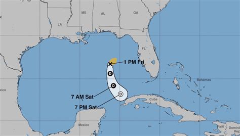
Tropical Storm Arlene, an early bloomer in the 2023 Atlantic hurricane season, formed in the Gulf of Mexico on Friday, marking a start before the official June 1st kickoff and exhibiting an unusual westward trajectory, defying typical storm patterns.
Arlene, the first named storm of the year, developed sooner than expected, with meteorologists closely monitoring its unconventional path. The National Hurricane Center (NHC) issued advisories regarding the storm’s location and intensity, pinpointing its position and projecting its movement. While initial forecasts suggested a northward turn, Arlene stubbornly tracked westward, a characteristic not typically observed in Gulf storms during this period. This atypical movement raised questions about the atmospheric factors influencing its behavior and the potential implications for regions along the Gulf Coast.
The storm’s formation before June 1st highlights the increasing unpredictability of hurricane seasons, potentially influenced by climate change and other environmental factors. Arlene’s existence serves as a reminder of the need for preparedness and vigilance as the Atlantic hurricane season unfolds. Despite Arlene’s relatively weak intensity, its unexpected path underscores the importance of heeding warnings from weather authorities and remaining informed about evolving conditions.
An Early Start and an Atypical Track
Tropical Storm Arlene’s emergence in late May signified an early commencement to the 2023 Atlantic hurricane season, which officially begins on June 1st and continues through November 30th. The storm’s formation ahead of schedule is not unprecedented, but it serves as a stark reminder of the potential for early-season activity and the need for proactive hurricane preparedness.
What distinguishes Arlene from typical Gulf storms is its westward trajectory. According to the National Hurricane Center, “The storm is moving toward the west near 5 mph (7 km/h), and this general motion should continue today.” Most storms in the Gulf of Mexico during the early season tend to move northward or northeastward, influenced by prevailing weather patterns and steering currents. Arlene’s westward path is an anomaly, prompting meteorologists to analyze the factors contributing to its unusual behavior. The presence of a high-pressure system to the north of Arlene could be deflecting the storm westward, preventing it from taking the more conventional northward route.
The NHC’s advisories indicate that Arlene’s intensity is relatively weak. It remains a tropical storm, and gradual weakening is anticipated as it encounters less favorable atmospheric conditions. However, even a weak tropical storm can produce significant rainfall, localized flooding, and gusty winds, particularly in coastal areas. The NHC emphasized the importance of monitoring Arlene’s progress, stating, “Weakening is forecast during the next few days, and Arlene is expected to dissipate by Sunday.”
Meteorological Analysis and Influencing Factors
Several meteorological factors are likely contributing to Arlene’s unusual track and intensity. Sea surface temperatures (SSTs) play a crucial role in hurricane formation and intensification. Warm ocean waters provide the energy and moisture that fuel tropical cyclones. While Gulf of Mexico SSTs are generally warm enough to support tropical development, regional variations can influence a storm’s behavior.
Atmospheric wind shear is another critical factor. Wind shear refers to changes in wind speed and direction with height in the atmosphere. Strong wind shear can disrupt a hurricane’s structure and weaken its intensity by tilting the storm’s core and preventing it from organizing effectively. The presence of moderate to strong wind shear in the vicinity of Arlene is likely contributing to its relatively weak intensity and westward movement.
The position and strength of high-pressure systems also influence hurricane tracks. High-pressure systems act as barriers, deflecting storms away from their centers. A strong high-pressure system located to the north of Arlene could be steering the storm westward, preventing it from moving northward or northeastward as typically observed.
Furthermore, the Madden-Julian Oscillation (MJO), a tropical weather pattern that circles the globe every 30 to 60 days, can modulate hurricane activity. The MJO consists of alternating phases of enhanced and suppressed convection. When the MJO is in a phase that favors hurricane development, it can increase the likelihood of tropical cyclone formation. Conversely, when the MJO is in a suppressing phase, it can inhibit hurricane activity. While the MJO’s influence on Arlene’s formation and track is not fully understood, it is a factor that meteorologists consider when assessing hurricane potential.
Impacts and Preparedness
Although Arlene is expected to remain a relatively weak tropical storm, it still poses potential hazards to coastal areas along the Gulf of Mexico. Heavy rainfall is the primary threat, with the potential for localized flooding in low-lying areas. Gusty winds could also cause minor damage to trees, power lines, and unsecured objects. Marine interests should be aware of the potential for rough seas and hazardous boating conditions.
Residents and visitors in coastal areas should monitor Arlene’s progress closely and heed any warnings or advisories issued by the National Hurricane Center and local emergency management agencies. It is essential to have a hurricane preparedness plan in place, which includes assembling a disaster supply kit, knowing evacuation routes, and securing property.
A disaster supply kit should contain enough food, water, medication, and other essential items to last for several days. It is also important to have a battery-powered radio or a weather radio to receive updates from the National Weather Service.
Knowing evacuation routes is crucial, especially for those living in coastal areas that are prone to flooding. Evacuation orders are issued when there is a significant threat to life and property. It is important to follow evacuation orders promptly and to bring essential items with you.
Securing property can help to minimize damage from high winds and flooding. This includes trimming trees, securing loose objects, and reinforcing windows and doors.
Long-Term Trends and Climate Change
The early formation of Tropical Storm Arlene raises questions about the potential impacts of climate change on hurricane activity. While it is difficult to attribute any single storm directly to climate change, there is increasing evidence that climate change is influencing hurricane behavior in several ways.
Warmer ocean temperatures provide more energy for hurricanes to develop and intensify. As ocean temperatures continue to rise due to climate change, it is likely that hurricanes will become more intense on average.
Sea level rise is also exacerbating the impacts of hurricanes. As sea levels rise, coastal areas become more vulnerable to storm surge, which is the abnormal rise in sea level during a hurricane. Storm surge can cause widespread flooding and significant damage to coastal infrastructure.
Some studies suggest that climate change may also be affecting hurricane tracks. Changes in atmospheric circulation patterns could alter the steering currents that guide hurricanes, potentially leading to more unpredictable storm paths.
While the exact impacts of climate change on hurricane activity are still being researched, it is clear that climate change is a significant factor that needs to be considered when assessing hurricane risk.
The early formation of Tropical Storm Arlene and its atypical westward track serve as a reminder of the need for vigilance and preparedness as the Atlantic hurricane season unfolds. Residents and visitors in coastal areas should monitor the storm’s progress closely and heed any warnings or advisories issued by weather authorities. It is also important to consider the potential impacts of climate change on hurricane activity and to take steps to reduce greenhouse gas emissions to mitigate future risks.
Conclusion
Tropical Storm Arlene, the first named storm of the 2023 Atlantic hurricane season, distinguished itself not only by its early formation but also by its unusual westward trajectory across the Gulf of Mexico. While the storm’s intensity remained relatively weak, its atypical behavior underscored the complexities of hurricane forecasting and the importance of staying informed about evolving weather conditions. The meteorological factors influencing Arlene’s path included the presence of a high-pressure system, wind shear, and sea surface temperatures. Although Arlene posed minimal direct threats, it served as a reminder of the need for preparedness and vigilance as the hurricane season progresses. The early formation of Arlene also raised questions about the potential impacts of climate change on hurricane activity, highlighting the increasing need for research and mitigation efforts to address the long-term risks associated with extreme weather events. Coastal communities should remain vigilant, monitor weather updates, and maintain preparedness plans to safeguard lives and property during the hurricane season.
Expanded Context and Background
To fully understand the significance of Tropical Storm Arlene and its unusual path, it’s important to delve into the broader context of hurricane formation, tracking, and the factors that influence their behavior. Hurricanes are among the most powerful and destructive natural disasters on Earth, and their impact can be devastating to coastal communities. Understanding the science behind these storms is crucial for effective forecasting and preparedness.
Hurricane Formation and Development
Hurricanes, also known as typhoons or cyclones depending on their location, are intense tropical cyclones that form over warm ocean waters near the equator. They are characterized by a closed, rotating circulation, strong winds, and heavy rainfall. The formation of a hurricane requires a specific set of environmental conditions:
-
Warm Ocean Waters: Hurricanes draw their energy from warm ocean waters with temperatures of at least 80 degrees Fahrenheit (26.5 degrees Celsius). These warm waters provide the necessary heat and moisture to fuel the storm’s development.
-
Atmospheric Instability: The atmosphere must be unstable, meaning that warm, moist air can rise freely and cool air can sink. This instability allows for the formation of thunderstorms, which are the building blocks of hurricanes.
-
Moisture: The atmosphere must be moist enough to provide the necessary water vapor for cloud formation and precipitation.
-
Low Vertical Wind Shear: Vertical wind shear, which is the change in wind speed and direction with height, must be low. Strong wind shear can disrupt the storm’s structure and prevent it from organizing effectively.
-
Pre-existing Disturbance: A pre-existing disturbance, such as a tropical wave or a weak low-pressure system, is often necessary to trigger the formation of a hurricane.
-
Coriolis Force: The Coriolis force, which is caused by the Earth’s rotation, is essential for the development of a hurricane’s rotating circulation. This force deflects moving objects (including air) to the right in the Northern Hemisphere and to the left in the Southern Hemisphere.
Once these conditions are met, a tropical disturbance can begin to develop into a tropical depression, which is a tropical cyclone with maximum sustained winds of 38 miles per hour (62 kilometers per hour) or less. If the tropical depression continues to strengthen, it becomes a tropical storm and is assigned a name. When the storm’s maximum sustained winds reach 74 miles per hour (119 kilometers per hour) or higher, it is classified as a hurricane (or typhoon/cyclone, depending on the region).
Hurricane Tracking and Forecasting
Hurricane tracking and forecasting have improved significantly in recent decades due to advancements in technology and scientific understanding. Meteorologists use a variety of tools and techniques to monitor and predict the behavior of hurricanes, including:
-
Satellite Imagery: Satellites provide valuable data about the structure, intensity, and movement of hurricanes. Geostationary satellites, which remain in a fixed position above the Earth, provide continuous monitoring of storms, while polar-orbiting satellites provide more detailed images of the storm’s interior.
-
Aircraft Reconnaissance: Specially equipped aircraft, such as the Hurricane Hunters operated by the National Oceanic and Atmospheric Administration (NOAA), fly directly into hurricanes to collect data about wind speeds, air pressure, and temperature. These data are used to improve hurricane forecasts.
-
Weather Models: Computer models use mathematical equations to simulate the behavior of the atmosphere and predict the future track and intensity of hurricanes. These models are constantly being improved and refined as new data become available.
-
Surface Observations: Surface weather stations, buoys, and ships provide data about wind speed, air pressure, and sea surface temperature. These data are used to validate and improve weather model forecasts.
The National Hurricane Center (NHC) is responsible for issuing forecasts and warnings for hurricanes in the Atlantic and Eastern Pacific basins. The NHC uses a combination of these tools and techniques to provide accurate and timely information to the public.
Despite the advancements in hurricane forecasting, there are still uncertainties and challenges. Predicting the intensity of a hurricane is particularly difficult, as it depends on a complex interplay of factors, including sea surface temperatures, atmospheric wind shear, and the storm’s internal dynamics. Hurricane tracks can also be difficult to predict, especially when the storm is interacting with other weather systems.
Factors Influencing Hurricane Tracks
Several factors influence the track of a hurricane, including:
-
Steering Winds: Hurricanes are steered by the prevailing winds in the atmosphere. These winds are typically determined by the position and strength of high- and low-pressure systems. In the Atlantic basin, hurricanes are often steered by the Bermuda High, a semi-permanent high-pressure system located over the western Atlantic Ocean.
-
Coriolis Force: The Coriolis force deflects hurricanes to the right in the Northern Hemisphere. This force causes hurricanes to move westward initially, and then to curve northward as they move further away from the equator.
-
Interaction with Land: When a hurricane makes landfall, it can be disrupted by the terrain. Mountains can block the storm’s path, while coastlines can alter its shape and intensity.
-
Ocean Temperatures: Hurricanes are fueled by warm ocean waters, so their tracks are often influenced by the distribution of sea surface temperatures. Hurricanes tend to move towards areas of warmer water.
-
Other Weather Systems: Hurricanes can interact with other weather systems, such as fronts and troughs, which can alter their tracks and intensity.
The Role of Climate Change
Climate change is expected to have a significant impact on hurricane activity in the future. Warmer ocean temperatures, rising sea levels, and changes in atmospheric circulation patterns are all expected to influence hurricane behavior.
-
Increased Intensity: Warmer ocean temperatures provide more energy for hurricanes to develop and intensify. Climate models project that the average intensity of hurricanes will increase in the future.
-
Sea Level Rise: Sea level rise is exacerbating the impacts of hurricanes by increasing the risk of storm surge flooding. As sea levels rise, coastal areas become more vulnerable to inundation during hurricanes.
-
Changes in Frequency: The impact of climate change on hurricane frequency is less clear. Some studies suggest that the number of hurricanes may decrease in the future, while others suggest that it may increase. However, even if the number of hurricanes decreases, the increase in intensity is expected to lead to greater overall damage.
-
Changes in Tracks: Changes in atmospheric circulation patterns could alter hurricane tracks. Some studies suggest that hurricanes may be moving poleward, meaning that they are more likely to impact areas further north or south of the equator.
Hurricane Preparedness and Mitigation
Hurricane preparedness and mitigation are essential for reducing the impacts of these storms. Individuals, communities, and governments all have a role to play in preparing for and mitigating the effects of hurricanes.
-
Individual Preparedness: Individuals should have a hurricane preparedness plan in place, which includes assembling a disaster supply kit, knowing evacuation routes, and securing their homes.
-
Community Preparedness: Communities should have emergency management plans in place, which include procedures for evacuation, sheltering, and disaster response.
-
Government Mitigation: Governments should invest in infrastructure improvements, such as seawalls and levees, to protect coastal areas from storm surge flooding. They should also implement building codes that require structures to be more resistant to hurricane-force winds.
-
Climate Change Mitigation: Reducing greenhouse gas emissions is essential for mitigating the long-term impacts of climate change on hurricane activity.
FAQ Section
1. What makes Tropical Storm Arlene’s path unusual?
Arlene’s westward trajectory across the Gulf of Mexico is atypical. Most storms in that region, especially early in the season, tend to move northward or northeastward. This westward track has prompted meteorologists to examine the specific atmospheric factors influencing its movement, such as high-pressure systems and wind patterns.
2. How strong was Tropical Storm Arlene?
Arlene was classified as a relatively weak tropical storm. While it posed a potential hazard with rainfall and gusty winds, it did not reach hurricane strength. The NHC forecasts indicated that the storm was expected to weaken further and dissipate.
3. When did Tropical Storm Arlene form?
Tropical Storm Arlene formed in late May, before the official start of the Atlantic hurricane season on June 1st. This early formation highlights the potential for activity outside the typical hurricane season dates.
4. What were the primary threats associated with Tropical Storm Arlene?
The primary threat from Arlene was heavy rainfall, which had the potential to cause localized flooding, particularly in low-lying coastal areas. Gusty winds were also a concern, potentially causing minor damage.
5. What is the National Hurricane Center’s role in monitoring storms like Arlene?
The National Hurricane Center (NHC) is responsible for issuing forecasts and warnings for hurricanes in the Atlantic and Eastern Pacific basins. They utilize satellite imagery, aircraft reconnaissance, weather models, and surface observations to track storms, predict their behavior, and provide timely information to the public and emergency management agencies.